
Technology and methods
across the life cycle of fishing gear

Over the past two decades, many ideas have been proposed to address the problem of ghost nets – from satellite tracking and smart buoys to sonar scanning and autonomous recovery systems. Most remained experimental, too costly or too fragile for everyday use at sea. What has emerged instead is a more realistic toolbox: simple, robust, low-cost technologies that can be deployed, repaired and improved directly within coastal communities.
Today, Redes Fantasma focuses on exactly this approach. Together with engineering partners and universities, we develop tools that can withstand real conditions, integrate local knowledge and evolve through continuous field testing. Our aim is not high-end perfection, but practical, scalable technology that enables prevention, locating and recovery where it matters most: in real-life marine environments.
Beach cleanings

Much more than a way to pass the time on the beach
Some people see beach cleaning as an activity that changes little – as if the ocean would simply bring more waste with the next tide. In reality, it is one of the most powerful forms of practical environmental action.
A beach clean creates visibility
Tourists and local communities see the problem directly, often for the first time.
It creates awareness
Every participant understands what accumulates on our coasts.
It is prevention
The waste we remove today does not return to the sea tomorrow.
And it is community building
A shared experience that brings together volunteers, schools, fishers – and even corporate teams, as several sponsors have used beach cleanings as meaningful team-building activities.


Urs Endress, the project initiator, actively partici-pating in beach cleaning

These actions also require coordination with local authorities. In Portugal, permissions typically involve DocaPesca or other maritime agencies, since not everyone is allowed to assemble on a beach and remove what they find. Proper authorization ensures that beach cleanings are safe, legal and aligned with coastal management practices.
Ocean Patrol in Peniche has shown what this can mean at scale. Their beach cleanings regularly involve dozens of participants – sometimes up to 80 people – and on record days they have collected nearly 1,000 kg of waste in a single day. What begins as a simple act of picking up debris becomes a coordinated community effort that strengthens coastal stewardship and directly reduces the burden on the marine environment.

Do you wish to contribute?
Your support helps fund marine conservation work, recovery of dangerous ghost nets and environmental education for sustainable impact.
Donations are primarily used to fund our work and projects. We keep administrative costs to a minimum so your support creates the greatest possible impact.
We also welcome legacy donations and bequests from individuals who wish to support long-term marine conservation efforts beyond their lifetime.
Redes Fantasma Schweiz is an officially recognized tax-exempt non-profit organization based in the Canton of Basel-Landschaft in Switzerland, and a PayPal-confirmed charity. Tax deductibility of donations applies according to Swiss regulations and may vary internationally. Further information regarding the association’s Swiss tax exemption can be found here.
Bank transfer
Basellandschaftliche Kantonalbank (BLKB)
SWIFT/BIC BLKBCH22
IBAN CHF CH12 0076 9442 7015 8200 1
IBAN EUR CH82 0076 9442 7015 8200 2
Redes Fantasma Schweiz
Holingen 125
4467 Rothenfluh
Switzerland
Thank you for your support!
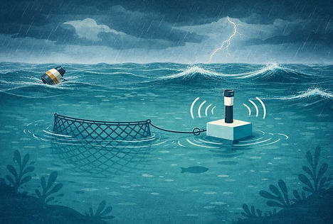
Location buoys

State of the art long range location buoys
Community based location system to find and track ghost nets
Across the EU, responsibility for lost fishing gear is shared: fishers are required to report losses and, where possible, retrieve gear without delay, while maritime authorities oversee safety and environmental protection. Marking gear is an important first step, but without reliable location data it remains difficult to act quickly and effectively. This is where tracking technology becomes essential.
Commercial tracking buoys are designed to track across large distances and operate independently of people. Their reliance on slow and expensive satellite technology and energy-hungry hardware makes them impractical for fishers to deploy at scale. Redes Fantasma changes this by developing an affordable system owned by the community.
A net can break free due to incidents like storms, vessel traffic, or equipment failure. In coastal waters, lost gear usually remains at the fishing site, rather than drifting far offshore. This makes it possible to use faster and energy-saving radio technology and avoid costly satellite communication altogether.

University of Applied Sciences
Ulm, Germany

Harald Molle
Product Development
Instead of sending data into space, a buoy can communicate with low-cost long-range radio receivers, similar to WiFi access points, placed along the shore, at the harbour, on boats, or even carried on drones. Since distances are typically less than 30 km, power consumption is minimal, which allows location updates every few minutes or less, instead of every few hours and without high satellite transmission fees.
This is the new solution – We empower the local community to build their own tracking network:


A drone acts as a relay when high waves disrupt the direct signal between buoy and shore.
Such an approach allows fishers, diving teams, coastal authorities, and volunteers to participate in preventing and locating ghost nets at scalable costs. The Redes Fantasma radio system turns tracking into a shared local capability – simple, scalable, and tailored to the realities of near-shore fisheries.
Multiple receivers increase reliability. If one misses the signal, another catches it. The buoys require very little maintenance, and battery life is measured in months rather than weeks. When waves are high after a storm, a drone can be used to extend the temporarily reduced communication range.
The Redes Fantasma radio system supports both proactive prevention and reactive recovery. The following applications are under development:
Application 1 – Proactive prevention (using the FloatLocator buoy)
The FloatLocator is attached to the fishing gear and activated before fishing begins. This assembly is deployed at the fishing site and the buoys always stay on the water surface. Since the FloatLocator sends its position via radio signal, the assembly becomes traceable from now on. When the fishing gear breaks free after an incident, the FloatLocator signals the sudden change in location and the community is alerted via an app: Accidental loss is turned into a recoverable event, and drifting gear can be located and retrieved easily while still on the surface.

The assembly of fishing gear and FloatLocator buoy (white box on the right) is deployed at the fishing site. The anchor buoy (striped cone on the left) holds the assembly in place.
When the net breaks free from the anchor buoy, the FloatLocator sends its position to trigger an alarm on the App. The net drifting on the water surface can be recovered.
Application 2 – Reactive recovery of floating gear (using the FloatLocator buoy)
Every vessel should carry a FloatLocator on board. Not only for its own gear, but to secure any drifting net or object encountered at sea. If someone encounters floating fishing gear on the surface, the FloatLocator can be activated and attached. It then transmits its position. Retrieval can be carried out by the owner (the fisher) or coordinated with NGOs and maritime authorities.

A lost floating net is found and is getting tagged with a FloatLocator. It starts sending a signal and can be retrieved.
Application 3 – Reactive recovery of submerged gear (using the DeepLocator)
The challenge is that it is often unclear whether a drifting net will remain afloat or eventually sink. In many cases, someone first attaches a FloatLocator to a freely drifting net to secure its position. When a fisher later reaches the site, they may realize that the net is too heavy to recover alone. If it becomes apparent that the net is likely to sink, the fisher can attach a DeepLocator as an additional safety measure. Nets may sink, for example, when floats are missing, the gear is heavily weighted, or marine growth has reduced buoyancy. This ensures that the net can still be found and recovered later, even if it disappears below the surface.
The DeepLocator is designed for gear that sinks below the surface, such as cages or nets. It is attached to the gear and descends together with it. After a predefined time, the transmitter is released, rises to the surface and starts transmitting its position. The transmitter remains connected to the submerged gear by a thin filament acting as an “Ariadne’s thread”. This allows the location of the gear itself, not just the floating transmitter.
Recovering submerged gear is significantly more complex than retrieving floating gear. The filament therefore supports targeted recovery by divers or Remotely Operated underwater Vehicles (ROVs).

The DeepLocator ist getting attached to a drifting piece of gear (cage, net or other). This can be done by anyone, not just fishermen.

When the gear sinks, the DeepLocator sinks with it.

After a predefined time, the DeepLocator emerges automatically to the surface and sends a signal. The net can be found and recovered.
FloatLocator: Proactive prevention and reactive recovery

DeepLocator: Reactive recovery of submerged gear

For those interested in the technical challenges, solutions and implementation details, we welcome enquiries via the contact form.
Sonar imaging

Locating ghost nets with sonar imaging
Ghost nets are often invisible from the surface. They drift below boats or rest against rocks, where currents, depth, and low visibility make them difficult, and sometimes dangerous, to locate.
Underwater imaging with camera systems is challenging due to poor lighting conditions and water turbidity. Sonar imaging overcomes these limitations. A sonar emits sound waves that travel through the water and are reflected by objects. By measuring the time delay between sending and receiving the signal, the sonar determines how far away an object is. In addition, information about the object’s shape, type, and position can be derived. More information on this topic is available on the website of deepoceaneducation.org: Sea floor mapping
A ghost net, for example, produces a characteristic pattern: It reflects and scatters sound differently than sand, rock, or vegetation. The data patterns from these reflections must be processed, and through sophisticated tomographic reconstruction, similar to methods used in medical imaging, a clear picture emerges showing where the net lies, how large it is, and how it interacts with its surroundings.
University of Applied Sciences
Ulm, Germany

Sabrina Lennartz
PhD student at THU
This approach helps divers and coastal teams plan safer and more efficient recovery missions. Instead of searching blindly, they can go directly to the correct location and assess whether removal is feasible and ecologically responsible.
Despite its potential, sonar array technology is still too costly for widespread use, and data processing remains too slow for routine, real-time detection in the field. Therefore, our partners at the University of Applied Sciences in Ulm (Germany) are working on improved methods for transforming data from simple sonar systems into high-quality images. The goal is to develop a framework that integrates multiple data sources to detect and classify lost fishing gear.
To further develop this imaging approach, research is being conducted in Germany within controlled test environments. Lakes and specially designed experimental sites allow sonar systems to be tested under reproducible conditions. These environments make it possible to systematically develop and optimize algorithms for image reconstruction, pattern recognition, and classification. The new knowledge forms the basis for transferring the technology to the more complex and dynamic marine environment at a later stage.

Experimental site: Swimming pool
A swimming pool is being used as a controlled test environment for the diving robot. It allows the team to validate basic functions, manoeuvrability, and sensor performance under safe, repeatable conditions. These trials help fine-tune the system before moving on to open-water testing.


Retrieval

Recovering ghost nets from the seabed or during descent is complex and potentially hazardous work. Today, such operations are typically carried out by specialised divers using adapted procedures to minimise risks for both people and the marine environment.
A safe retrieval starts with reliable localisation. Where location buoys or GNSS data exist, vessels can navigate directly to the site. Where no position data is available, sonar imaging can still detect and map ghost nets on the seabed, allowing the operation to be planned before anyone enters the water.
Retrieval is never drag and pull. The process begins with a structured site assessment to understand how the net is lying, whether it is drifting, snagged, or already integrated into the habitat. Only when removal is considered safe and ecologically justified does the recovery proceed.
In the long term, automation is essential to reduce human exposure in complex ghost-net retrieval operations. Underwater drones for detection and retrieval are developed and tested at various institutes and companies, including our partner THU in Ulm and may be applicable as a first step.
Once a target area is confirmed, sonar provides a first situational picture: net shape, seabed structure, and whether the net is likely free or entangled. For the final decision and precise handling, optical inspection is usually required. Today this is done either by divers or by commercially available underwater drones with cameras, enabling close-range assessment without immediate diver exposure.
Only after this inspection can a recovery plan be executed responsibly. Divers may carefully free a net and guide it to the surface using ropes or buoyant lines. In some cases, marine biologists or public authorities assess whether long-sunken nets have become so embedded in local ecosystems that removal would cause more harm than leaving them in place.

Photo: Mischa Schwarzmeier
To keep people out of risk zones and lower cost over time, retrieval will increasingly use underwater robots with cameras and manipulator arms. ETH Zurich’s “ReefRanger” shows how delicate robotic intervention in sensitive marine environments is becoming feasible.
Waste handling

Recovering lost fishing gear and marine debris is only part of the solution. Without responsible waste handling, collected materials can simply be moved from the ocean to land – with the risk of re-entering the environment in future rain or tide events. Redes Fantasma therefore treats waste handling and recycling as a core component of its systematic approach.
Following retrieval, materials are sorted and classified by type – fishing nets and ropes, plastics, metals, and other debris – to ensure that recyclable components are separated from residual waste. This sorting step is crucial: it informs decisions about which items can be recycled, repurposed, or must be disposed of through licensed channels.
In Portugal, organisations like Ocean Patrol actively practise this approach after coastal and underwater clean-ups. Collected waste is separated and classified, reducing the amount sent to landfills and enabling higher recycling rates.
Proper waste handling begins immediately after a clean-up or retrieval action:
-
On-site classification
Items are grouped by material type to avoid contamination and to maximize recycling potential.
-
Temporary storage
Waste is stored securely and documented to prevent dispersal and to support traceability.
-
Transfer to licensed facilities
Recyclable and non-recyclable fractions are handed over to authorised operators who comply with Portuguese and EU waste regulations.
-
Upcycling and reuse
In partnerships with recycling centres and community initiatives, recovered materials may be repurposed for example, old fishing nets can be transformed into useful products or artworks that raise awareness and support local engagement.
Waste handling is not merely a technical task. Through workshops and community events, Ocean Patrol and its partners promote deep awareness of recycling, upcycling and waste management practices, encouraging local stakeholders to adopt sustainable behaviours and contribute to a circular economy.
Ultimately, rigorous waste handling converts a field action into measurable impact, closes the loop between recovery and responsible disposal, and reinforces the integrity of the entire Redes Fantasma system.